While putting together the new UI, I've taken the opportunity to do something I'd been thinking of for a while and quadrupled the size of the global map. This obviously allows for more features and detail in each world, but it also makes the regional map a bit more realistic. If I keep the regional map exactly as it was, it means that the scale has changed: each pixel on that map now represents an area of one square kilometre. I think the features I already have on the regional map, particularly the mountain ranges, make more sense if this is the scale.
However, increasing the global map size does show up some limitations of the global terrain generation. The basic continents are made by creating long mountain ranges and sort of spreading land out from them, then adding or removing extra bits of land. However, this doesn't scale up tremendously well.
They look pretty blobby. As things stand, UW improves their appearance by creating a diamond-square fractal and then using that to remove sections of land, to create jagged coastlines:
That gives us much nicer-looking landmasses. But now that the scale has changed, they simply look too small to be proper continents. I can't just scale up this method, because using the fractal to remove land will simply fragment everything. (I don't want to use it to add land, because then I'll just end up with a fractal global map, which is unrealistic in a different way.) Consider an actual world map:
The bits I've circled in red are the areas where it resembles the areas on my maps where the fractal is used to cut away the land. It's a relatively small proportion of the world. The methods I'm using at the moment can make interesting world maps, but they can't really generate something like Africa.
So what I need is a way to create the shapes of continents that don't look like vague blobs, and are interesting and varied, but without being all jagged and broken up. Then I can combine these with the methods I already have to get maps with all different kinds of land masses, just like reality.
It occurred to me that I already had a method of generating shapes a little like this:
large lakes on the regional map. There, we take a large, simple shape with lots of straight lines, and distort it into something more natural-looking. Could we use a similar technique to create continents?
Well, first we need a shape to manipulate. A fairly straightforward way of doing this is with a
Voronoi diagram. Now,
I said at the start that I wasn't going to use those, but while I'm not storing the actual terrain
as a Voronoi diagram, I can still use a Voronoi diagram to generate shapes that I subsequently manipulate.
It's a simple thing to program, even for me, and generates this sort of thing:
That would look lovely hanging on the wall. Anyway, as it stands, this diagram has an area equivalent to the global map. What I'm going to do is use it to create the shape of a continent, which will then be pasted onto the global map, not necessarily in the same position that it occupies here. The cells of this diagram are pretty large. I can easily make them smaller, of course, by having more of them, but I really only need a rough outline for our continent.
Now I need to pick out the cells that will make up our continent. A standard way of doing this kind of thing is to use Perlin noise or something similar, but I don't want that kind of shape and in any case I don't need anything that elaborate because most of the interest of this shape will come from the Voronoi cells, as they're quite large. Just a few randomly-placed circles should be enough:
Now we just keep the Voronoi cells that that blob goes over, and that makes the basic outline of our continent. That gives us results like these:
And this is just what I wanted - they already look like very stylised continents.
So we have a basic continent shape. Now we need to disrupt its borders as we did the lakes, so it looks more natural. This will require less disruption than we did then, in fact, because we aren't trying to disguise a gridlike original shape.
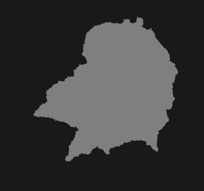
It takes a lot of tinkering to get something reasonable. I try to vary many of the variables not only from one continent to another, but also within a single continent, so their coastlines don't look too uniform - there should be some smoother bits, and some more jagged bits. This gets me shapes like these:
I'm pretty pleased with these - I think they look fairly believable as continents of various shapes and sizes. The little islands that sometimes appear around them are a happy accident, the result of the fill method. When the outline of the continent is drawn, I draw a box around it, and then fill inside that box, to make a sort of negative of the continent. Then I reverse that for the final version. Since the outline can sometimes cross over itself while making especially extravagant squiggles, this can leave the insides of loops as isolated bits of land on the final shape. You'll notice there are also some squiggles of blankness inside these continents, but it's easy to remove these.
The next step is to put these onto the world map. Rather than just slap a few on at random locations, I select just one or two focal points on the world map. At each focal point, a continent will be placed. Around these central continents, other continents will be placed, either overlapping the central ones or a little way off from them. In theory, this allows us to mimic the real world map, where continents cluster in groups, with wide oceans between the groups.
The results aren't perfect, but some of them are already starting to look like potentially interesting world maps (bear in mind these are made merely by the process just described, without any removal of inland seas or shifting the map or anything):
Clearly there's still a lot of finessing to do, but I think this method has the potential to produce a good base for global maps once we add back in all the other details.