
I've made a few small tweaks to the program to improve the appearance of regional maps:
(1) Low mountains and hills are more likely to use wider peaks, giving them a more rounded and gentle appearance compared to higher ridges and peaks.
(2) Transform faults in mid-ocean ridges have been turned off, at least for now - they look too messy most of the time.
(3) Shading on ocean seabeds has been reduced for small differences in elevation, to avoid the kind of artifacts seen in the second map here.
(4) Semi-arid areas are depicted as slightly greener.
The main addition, though, is one I was considering for a while: custom worlds. It is now possible to import your own maps into Undiscovered Worlds and have it calculate the climates, rivers, and so on. You can then explore it, and export maps, just as if it were a world generated from scratch.
Here's what the new import screen looks like:

So, for example, if the user draws a single line on their mountains image and imports it into UW, it creates mountains that look like this at the regional scale:


As you can see, the import screen also allows you to generate various features on your map once you've imported the heightmaps. You can remove straight coastlines, generate continental shelves and mid-ocean ridges, add random variation to both sea beds and the land if desired (this means that you could import just flat heightmaps for the land or sea and have UW create variation in elevation, if you don't want to do it yourself). Finally, you can add smaller mountain ranges, hills, and also island chains, all randomly placed.
When you press the big button at the bottom, UW does a few additional processes such as removing depressions and adding gentle slopes to the land, and then calculates all the climates, as well as the river courses, lakes, and so on. Once that's done the world is finished and you can explore it at the regional level, and of course export maps with your preferred colour schemes, to do with as you will.
With luck, this should provide enough control for hopeful Slartibartfasts to sketch out the outlines of a world in whatever paint program they like, and then have UW fill in all the details.
I thought I'd test it out myself. I adapted this map of the Third Age of Arda to import into Undiscovered Worlds. I only did basic land outlines, and mountain ridges - the scale probably isn't quite right but I tried to get it as close as possible. I had to pretty much guess the heights of the mountains. Importing these two sets of data into UW, I added random elevation, and also random hills scattered about, so it won't exactly match Tolkien's physical terrain (to the extent that he ever specifies it precisely at all). Also, I cheated a bit by making the two large salt lakes in Tolkien's map into patches of actual sea, to ensure they appeared in the right locations.
I tried running this through UW a number of times and found that the results could vary quite a lot, depending on how the winds were generated (it's pretty random), as well as depending on where random hills get plonked down, plus all kinds of other small differences that can translate into quite significant variation. In some versions, Gondor was a huge desert. In some, the River Anduin swerved west and flowed out through the Gap of Rohan.
Here's a version that seemed to me quite pleasant-looking:

Obviously the only bit we really care about is the northwestern part of Middle Earth, so this is what that area looks like:

Here are the climates of that same region (using this colour scheme):
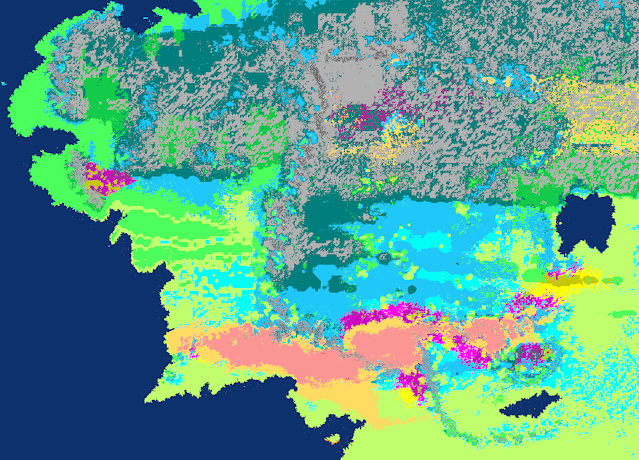
Obviously it's hard to say how many of the discrepancies are down to Tolkien's errors as a world builder, or down to UW's deficiencies as a world modeller, or down to my own errors in translating the maps to match the projection used here. Probably it's a combination of all of these factors.
Anyway, there's a quick demonstration of what you can do with the import feature. I hope people will find it useful who would like to sketch out a world and then have the computer calculate the climates and show roughly what it might look like.
This is very impressive!
ReplyDeleteThank you! Now it's time for bug-hunting. Yay!
DeleteNow you're talking my language! I think it will be hard to come up with mountains and rivers both reasonably realistic and accurate to Middle-earth since, after all, A Wizard Did It.
ReplyDelete